County Down
| County Down Contae an Dúin Coontie Doun[1] |
||
 |
||
|---|---|---|
| Motto: Absque Labore Nihil (Latin) "Nothing Without Labour" |
||
| Location | ||
|
||
| Statistics | ||
| Province: | Ulster | |
| County seat: | Downpatrick | |
| Area: | 2,448 km2 (945 sq mi) (12th) | |
| Population (est.) | 516,000 (4th) | |
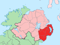
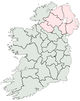
County Down (named after its county town, Downpatrick) is one of six counties that form Northern Ireland, situated in the north-east of the island of Ireland. Adjoined to the south-east shore of Lough Neagh, the county covers an area of 2,448 km², with a population of approximately 516,000. It is also one of the thirty-two counties of Ireland, lying within the historical province of Ulster.
Although Downpatrick is the county town, the largest town is Bangor. Newry lies on the boundary between counties Down and Armagh, while Lisburn and Belfast lie on the boundary between counties Down and Antrim. Down contains both the southernmost point in Northern Ireland (Cranfield Point) and the easternmost point in Ireland (Burr Point).
The county borders County Antrim to the north, the Irish Sea to the east and County Armagh to the west. It is one of only two counties of Ireland to presently have a majority of the population from a Protestant community background, according to the 2001 census. The other is County Antrim.
Contents |
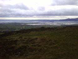
Geography
Down contains two significant peninsulas: Ards Peninsula and Lecale peninsula.
The county has a coastline along Belfast Lough to the north and Carlingford Lough to the south (both of which have access to the sea). Strangford Lough lies between the Ards Peninsula and the mainland. Down also contains part of the shore of Lough Neagh. Smaller loughs include Lough Island Reavy.
The River Lagan forms most of the border with County Antrim. The River Bapp also flows through the southwestern areas of the county. Other rivers include the Clanrye and Quoile.
There are several islands off the Down coast: Mew Island, Light House Island and the Copeland Islands, all of which lie to the north of the Ards Peninsula. Gunn Island lies off the Lecale coast. In addition there are a large number of small islands in Strangford Lough.
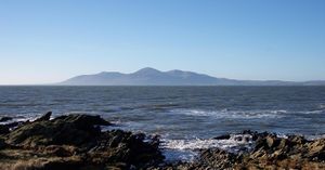
County Down is where, in the words of the famous song by Percy French, "The mountains of Mourne sweep down to the sea", and the granite Mourne Mountains continue to be renowned for their beauty. Slieve Donard, at 849 m (2,785 ft), is the highest peak in the Mournes and in Northern Ireland. Another important peak is Slieve Croob, at 534 m (1,752 ft), the source of the River Lagan.
Places of interest
- An area of County Down is known as the Brontë Homeland (situated between Rathfriland and Banbridge, where Patrick Brontë had his church), after Patrick Brontë (originally Brunty), father of Anne, Charlotte, Emily Brontë, and Branwell Bronte. Patrick Bronte was born in this region.
- The city of Newry in the south of the county contains St Patrick's (Church of Ireland, 1578), overlooking the city centre from Church street, on the east side of the city, which is considered to be Ireland's first ever Protestant church. Newry is also the home of the first summit-level canal ever to be built in the British Isles.
- Down is also home to Exploris, the Northern Ireland Aquarium, located in Portaferry, on the shores of Strangford Lough, on the Ards Peninsula.
- The Old Inn in Crawfordsburn is one of Ireland's oldest hostelries, with records dating back to 1614. The inn claims that people who have stayed there include Jonathan Swift, Dick Turpin, Peter the Great, Lord Tennyson, Charles Dickens, Anthony Trollope, former US president George H. W. Bush, and C. S. Lewis, who honeymooned there.[2]
- Scrabo Tower, in Newtownards, was built as a memorial to Charles Stewart, 3rd Marquess of Londonderry.
- Saint Patrick is reputed to be buried at Down Cathedral in Downpatrick, reputedly alongside St. Brigid and St. Columba.
- Saul, County Down (from the Irish: Sabhall meaning "Barn" – where Saint Patrick said his first mass in Ireland
Settlements
| Historical populations | ||
|---|---|---|
| Year | Pop. | %± |
| 1659 | 15,183 | — |
| 1821 | 325,410 | 2043.3% |
| 1831 | 352,012 | 8.2% |
| 1841 | 361,446 | 2.7% |
| 1851 | 320,817 | −11.2% |
| 1861 | 299,302 | −6.7% |
| 1871 | 277,294 | −7.4% |
| 1881 | 248,190 | −10.5% |
| 1891 | 224,008 | −9.7% |
| 1901 | 205,889 | −8.1% |
| 1911 | 204,303 | −0.8% |
| 1926 | 209,228 | 2.4% |
| 1937 | 210,687 | 0.7% |
| 1951 | 241,181 | 14.5% |
| 1961 | 266,939 | 10.7% |
| 1966 | 286,631 | 7.4% |
| 1971 | 311,876 | 8.8% |
| 1981 | 417,978 | 34.0% |
| 1991 | 454,411 | 8.7% |
| 2001 | 489,004 | 7.6% |
| [3][4][5][6][7][8] | ||
Cities
(population of 75,000 or more at 2001 Census)[9]
- Newry
- Belfast- East
Large towns
(population of 18,000 or more and under 75,000 at 2001 Census)[9]
- Dundonald
- Newtownards
- Bangor (although exceeds 75,000 people)
Medium towns
(population of 10,000 or more and under 18,000 at 2001 Census)[9]
- Banbridge
- Downpatrick
- Holywood
Small towns
(population of 4,500 or more and under 10,000 at 2001 Census)[9]
- Ballynahinch
- Carryduff
- Comber
- Donaghadee
- Dromore
- Kilkeel
- Newcastle
- Warrenpoint
Intermediate settlements(population of 2,250 or more and under 4,500 at 2001 Census)[9]
Villages(population of 1,000 or more and under 2,250 at 2001 Census)[9]
|
Small villages or hamlets(population of less than 1,000 at 2001 Census)[9]
|
|
|||||||||||||||||||||||
Subdivisions
Baronies
- Ards Lower (from the Irish: Aird)
- Ards Upper
- Castlereagh Lower
- Castlereagh Upper
- Dufferin (from the Irish: Duifrian)
- Iveagh Lower, Lower Half (from the Irish: Uíbh Eachach)
- Iveagh Lower, Upper Half
- Iveagh Upper, Lower Half
- Iveagh Upper, Upper Half
- Kinelarty (from the Irish: Cineál Fhártaigh)
- Lecale Lower (from the Irish: Leath Cathail)
- Lecale Upper
- Lordship of Newry
- Mourne (from the Irish: Múrna)
Parishes
Townlands
Sport
See also
- Abbeys and priories in Northern Ireland (County Down)
- List of civil parishes of County Down
- List of places in County Down
- List of townlands in County Down
References
- ↑ DCALNI.gov.uk
- ↑ Crawfordsburn Old Inn website
- ↑ For 1653 and 1659 figures from Civil Survey Census of those years, Paper of Mr Hardinge to Royal Irish Academy March 14, 1865.
- ↑ Census for post 1821 figures.
- ↑ Histpop.org
- ↑ NISRA.gov.uk
- ↑ Lee, JJ (1981). "On the accuracy of the Pre-famine Irish censuses". In Goldstrom, J. M.; Clarkson, L. A.. Irish Population, Economy, and Society: Essays in Honour of the Late K. H. Connell. Oxford, England: Clarendon Press.
- ↑ Mokyr, Joel; O Grada, Cormac (November). "New Developments in Irish Population History, 1700-1850". The Economic History Review 37 (4): 473–488. doi:10.1111/j.1468-0289.1984.tb00344.x. http://www3.interscience.wiley.com/journal/120035880/abstract.
- ↑ 9.0 9.1 9.2 9.3 9.4 9.5 9.6 "Statistical classification of settlements". NI Neighbourhood Information Service. http://www.ninis.nisra.gov.uk/mapxtreme_towns/statistical%20classification.htm. Retrieved 23 February 2009.
Further reading
- Harris, Walter (attributed). 1744. The Ancient and Present Stare of the County of Down...'Dublin.
- The Memoirs of John M. Regan, a Catholic Officer in the RIC and RUC, 1909–48, Joost Augusteijn, editor, District Inspector, Co. Down 1930s, 1919, ISBN 978-1-84682-069-4.
External links
- County Down at the Open Directory Project
- County Down tourism
- Armagh and Down tourism
- Culture Northern Ireland - Industrial Heritage of County Down
- Down Gaelic Athletic Association/Cummann Lúthchleas Gael Coiste An Dún
- Genealogy indexes for County Down
- Ardglass fishing port on East Down coast
|
||||||||
|
||||||||||||||||||||